We carry out social survey and prepare Rehabilitation Action Plan as per the R&R policy of the State. We also undertake preparation of land acquisition plan.
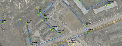
We offer a wide range of GIS (Geographic information system) services to both government and private sector clients to enable spatial analysis, manage large datasets, and display information in a map/graphical form in various engineering verticals.
We have the necessary expertise in the conceptualisation, design and development of robust, scalable and customized geospatial solutions and have provided services to public sectors.
CAPABILITIES
We have forayed in to challenge to manage large datasets for displaying information in a map/graphical form in a scalable and customized geospatial solution and due to dedication and creativity of our team, we manged to create an interactive GIS data base. Such past experience in treading in the new territory and managing the data has given us the confidence to delve in to more challenging assignments.
GIS
utility mapping
Remote Sensing
MIS Data Preparation
Application Development
Data Migration
Mobile application of GIS
Web & Desktop based GIS
Carrying out cadastral survey and GIS map for areas and alignments
Implementation of Desktop & web based Geographic Information System (GIS) Application